Wayland's Smithy, The Ridgeway and a very nice cafe

Last week we dodged the rain, as if we had some form of magical powers or more likely, blind luck. We had a very special destination in mind, one that I had last visited with my parents as a young child but could barely remember, if truth be told.

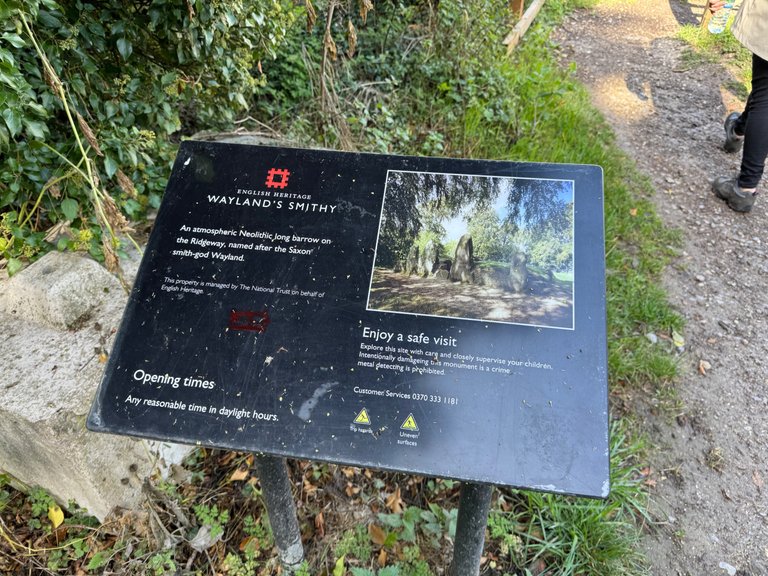
Wayland Smithy is an ancient, Neolithic long barrow perched high on the Wessex Downs, near the Oxfordshire village of Ashbury and close to the Uffington White Horse. Parking is officially the same car park for the White Horse and Uffington castle, so we set our satnav for there and drove along the M4 from our home near Reading, coming off at the Hungerford junction. The route follows another ancient piece of history, Ermin Street (also known as Margary 41), one of the many Roman roads that criss-cross our country. Eventually we took a turning off this main road and the roads become narrower, more windy, more hilly as we started to ascend the downs. The area feels ancient, lost in time, cottages that look like they belong in medieval fairytales rather than the modern world.
After awhile, we found ourselves in Ashbury, a small village with ancient history, a Saxon past and now part of Oxfordhire, well it has been for 55 years or so. The county boundaries changed in 1974, what was a Berkshire village became part of Oxfordshire. The area is also known as, for obvious reasons, "The Vale of White Horse". A number of famous people come from around here, especially one of my all time favourites, the poet Pam Ayers.
We note there is a cafe as we drive through, following the signs for White Horse and Wayland Smithy perhaps we might come back to it later?
Turning right up a steepish hill, we found the spacious car park (free for National Trust members like us, take your card) on the left and the views from there are expansive. You can see Oxfordshire, Berkshire, Wiltshire and maybe even Gloucestershire? I might be exaggerating there?
We walked up the grassy hill in the direction of the White Horse, the views opening up even more, in one direction we could see the peak of the iron age fort known as Uffington Castle, the White Horse, not quite visible from our position, actually just beneath us, over the prow of the hill. The overall hill is known as "Dragon Hill", the entire area being a significant historical site, there is a lot of history to unpack here. To climb to the very top of the hill, is said to take about an hour and a half, if you follow the circular route. I vow to do so in the future.
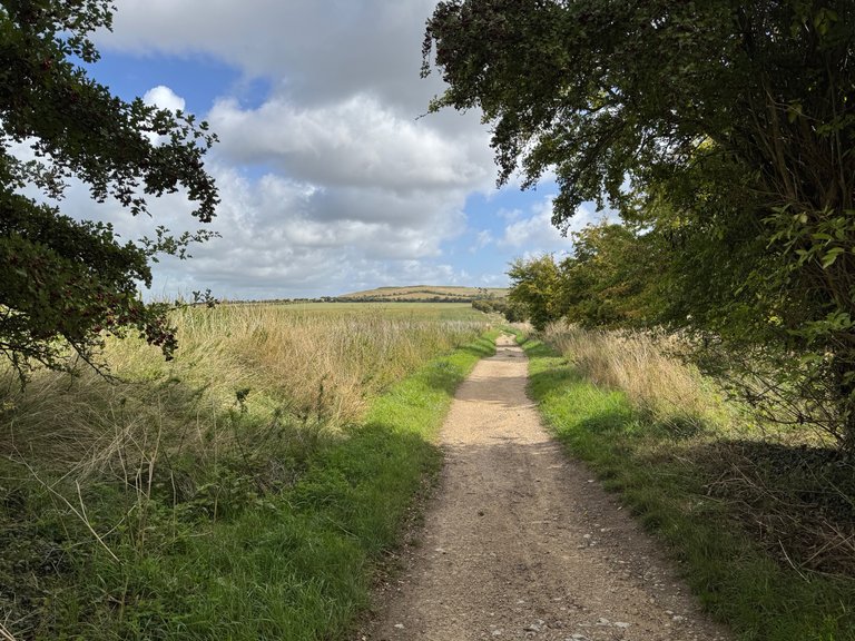
However on this particular occasion, we were walking up onto the ridge, perhaps the spine of the dragon or so to speak, in order to follow the Ridgeway in the other direction for about 1.5 miles.
The Ridgeway has fascinated me for many years and we have walked segments of it in the past. It starts in Avebury, Wiltshire, home of one of our beloved stone circles and treks eastwards for 87 miles to Ivinghoe Beacon, Buckinghamshire. Whilst the modern day long distance path is no more than 50 years old, the underlying ancient path that it follows is said to be 5,000 years old, once stretching from Dorset to The Wash in Norfolk, some 250 miles in length.
As we started to tread the old route, i couldn't help but notice the stones and old bricks beneath my feet, how old were they? I thought of the drovers and merchants who would have followed this trail from one settlement to the next, ghosts of the past, did I hear their whispers in the wind?
As I said at the start, we were lucky with the weather, the day was lovely, the sky was blue with a few clouds but there were some heavier cumulae looming to the North, bad weather was not far away. So we plodded on, slightly worried that despite the initial signposts being very helpful, Wayland Smithy straight ahead about ten minutes ago but we reached a road, the four directional signpost told us that there was a footpath that way, that way, that way and that way. Looking at the Google Map (note to self, re-subscribe to OS Maps, it's much better) I could see we were getting closer to the Smithy.
We crossed the road and looking back realised we had climbed quite a steep path, it just didn't feel like we had, I was quite pleased about it. The summer had been so hot, that we hadn't walked all that much and our legs should have been screaming for mercy by this point but they weren't. Small wins hey.
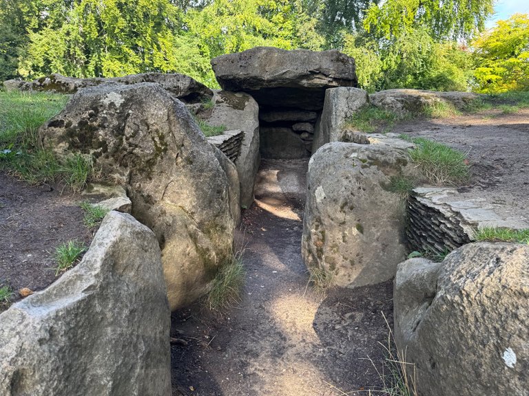
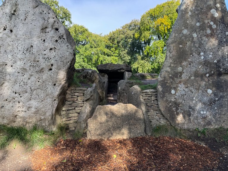
Wayland Smithy
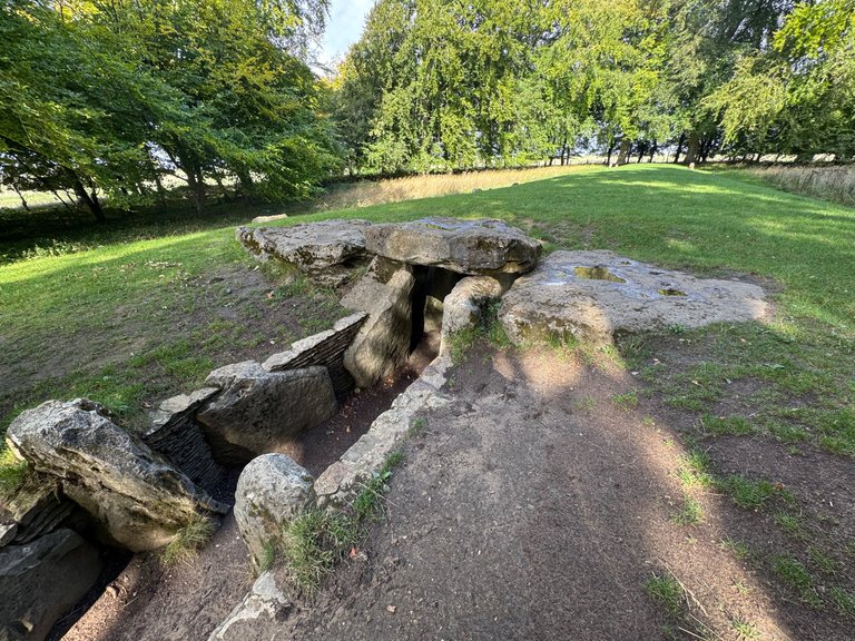
We had found it, as all of a sudden we saw the sign with the location's history and a nice new wooden gate. We followed the footpath up to the large wooded copse to find the ancient stones, towering above my head at about 7 foot tall (I'm 5'10).
It is a neolithic long-barrow, a burial site dating back some 5,300 years, which means it would have been there quite some time before the original Ridgeway existed. The stones are Sarsen, it has a "forecourt" and several chambers. Excavations in the past have revealed both human remains and evidence of pottery.
The site derives its name from Wayland the Smith, a figure from Anglo-Saxon and Norse mythology. According to legend, Wayland was a supernatural blacksmith who was imprisoned on the site. Folk tradition claims that if you leave a horse at the smithy with a coin, you'll return to find the horse shod and the money gone, though you'll never see the mysterious smith himself.


I don't have a horse and wouldn't try this out if I did, I am a little bit superstitious.
It has been the setting for TV productions in the past, including The Moon Stallion
We spent quite awhile at the ancient site, waling around, taking photos and I even recorded some sounds for my other project the #hivesoundlibrary and then we headed back to the car. As soon as we were seated and belted up, the rain started.
Fruit galore
Despite the hot summer we’ve had, the abundance of fruit this September, is nothing short of amazing. It might be the mixture of constant rain at the start of this year, then the “drought”?


Feeling peckish
We headed back into Ashbury, our tummies needed filling and were keen for a coffee or two. This is where we discovered The Baking Bee a deli, bakery and cafe (didn't have a loo though, just to make you aware) and had a very nice lunch there.
The weather took a turn for the worse. So we headed for home.
Other notes
I mentioned the Margary 41 route above when talking about Ermin Street without much more of an explanation. Ivan Margary was a historian who did extensive work on Roman roads and cultivated a system known as "Margary numbers", comparable with the numbering system we use for motorways and A roads in modern Britain. https://en.wikipedia.org/wiki/Margary_numbers
Maybe there is a Roman road near you?
I plan to walk the whole Ridgeway. I have said this of The South West Coast path too in the past... so don't hedge any bets on this.
You can check out this post and your own profile on the map. Be part of the Worldmappin Community and join our Discord Channel to get in touch with other travelers, ask questions or just be updated on our latest features.
That's quite a place with all that history. We've been to Avebury, but not sure we ever made it to this place. We've been getting value from our National Trust lately. You really only have to visit about 3 places to save the membership fee. Maybe some day we'll do a grand tour of special sites around the UK.
!BEER
It’s well worth the money, is the a NT. a grand tour world be superb.
!PIZZA
$PIZZA slices delivered:
@nicklewis(1/10) tipped @steevc
Come get MOONed!
Beautiful place. 😊
You been?
No I haven't but maybe it's worth a visit.
We recommend it 😀
Ohh I love Wayland Smithy ❤️
You could feel the history almost and I wouldn’t want to go there after dark, must be a little spooky!