Saving Cities Billions with Smarter Infrastructure Planning
Can Open-source Data & Simulations Help Cities Invest Smarter?
The purpose of this post is to open up readers' minds to possibilities.
Starting a project, especially in infrastructure, often comes with one major roadblock which is cost.
But what if I told you that you can do more with less by thinking smarter and leveraging the power of open data and simulation tools?
Lets explore how I used open-source tools to create a cost-effective model that could help cities save billions from flood-related disasters.
💸 The Problem
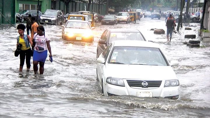
Image Source
Flooded City in Nigeria
In 2024 alone, natural disasters inflicted $310 billion in global economic losses—yet only $135 billion was insured.( Information Source )
One of the biggest contributors to these losses? Urban flooding.
As urbanization and global warming intensifies, flood becomes increasingly frequent, intense, and costly. It ravages infrastructure, shuts down businesses, people living in the neighborhood are forced to flee, and that comes at an enormous cost to the government.
What if we were able to anticipate and prevent those damages ahead of the incoming floodwaters?
But what if we could predict and prevent these damages before the floodwaters even rise?
💡 Where Tech Meets Finance
Recently, I have been researching and working on a project.
How to bridge the gap between tech and finance while considering cost effectiveness. I used a GIS(Geographic Information System) approach to tackle this.
It's pertinent to first understand the problem and the parameters that contribute to it in order to have a solution.
Flood is typically affected by the Elevation of a surface, Urbanization, Rainfall and capacity of drainage.
Therefore, the data that should be sourced for is:
- Elevation (how high or low an area is)
- Rainfall patterns
- Urbanization (buildings, roads, impermeable surfaces)
- Drainage capacity
To model these, I sourced free, reliable data from public datasets:
✅ Rainfall Data from CHIRPS and NASA’s GPM
✅ Elevation Data from the Shuttle Radar Topography Mission (SRTM)
✅ Drainage Networks from OpenStreetMap + Overpass Turbo
✅ Land Use Data from the European Space Agency’s WorldCover
All of these were plugged into HEC-RAS, a hydraulic simulation tool, to model how water flows through urban areas and to identify flood-prone zones.
💰 Financial & Economic Implications
- 🚧 Roads collapse
- 🏢 Businesses shut down
- 👨👩👧👦 Families are displaced
- 💸 Governments spend more on emergency relief than prevention
In places with weak infrastructure and limited insurance coverage—especially in the Global South—these impacts are even worse.
But through predictive tools developed from open-source data, cities can:
1. Plan smarter
2. Allocate resources better
3. Build more resilient systems
With my model, combining OpenStreetMap, Overpass Turbo, and HEC-RAS, urban planners now have an inexpensive tool for simulating flood risk and investment planning before the disaster occurs.
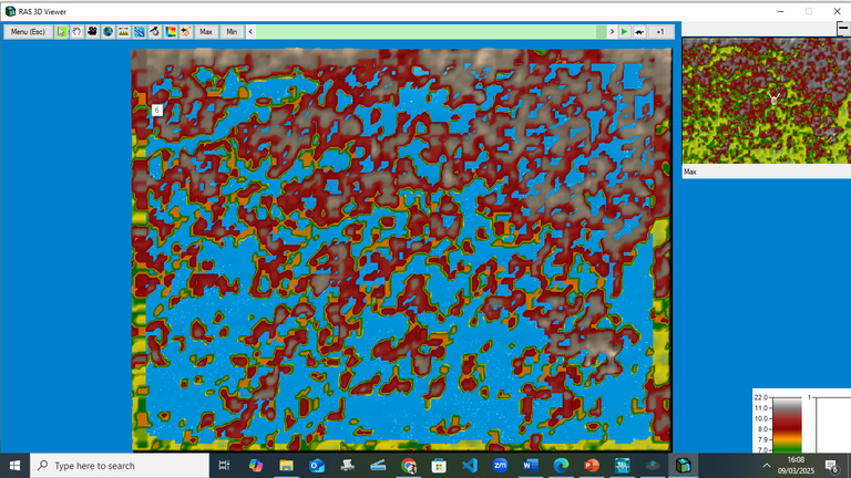
This is an Inundation Map that shows Flood Prone Areas🌊
Screenshot gotten from my Model
🔗 Potential for Blockchain Use
I’ve also been thinking about how the blockchain can take this even further.
- A decentralized approach could be used to store Permanent historical records of existing and proposed drainage, land use changes, and insurance claims
- Smart contracts that automate flood insurance payouts
- Tokenized incentives to fund local data collection and climate adaptation projects
Trust, transparency, and participation is a no-brainer.
🌐 Real-World Application Idea
Thinking further about it, imagine a web app that:
- Maps out flood-prone areas
- Allows users to report flood severity in real time
- Helps services like Uber or Bolt reroute traffic during heavy rainfall
- Gives urban planners better insights based on crowdsourced data
This approach gets the community involved 💪🏾
💬 Let’s Interact
What are some other ways we can leverage open source data and also blockchain tools to solve real-world problems like flooding?
Drop your thoughts below, I’d love to hear from you! 🗣️💭
EXTRA
Terminologies used in this Post
📘 What These Terms Mean 🧠
- GIS (Geographic Information System): This is a system for capturing, storing, and analyzing spatial or geographic data.
- CHIRPS: A rainfall data set combining satellite imagery and ground station data for better accuracy in regions without sensors.
- DEM (Digital Elevation Model): A 3D representation of a terrain's surface—used to understand how water will flow.
- OpenStreetMap (OSM): A free, editable map of the world built by volunteers, used to get drainage and road data.
- Overpass Turbo: A tool to extract specific map data from OpenStreetMap. (I used this as a media to get drainage data from OSM)
- HEC-RAS: A software by the U.S. Army Corps of Engineers that models the flow of water in rivers and urban environments.
- Smart Contracts: Code written by developers that self-execute when certain conditions are met.
- Token Gifting: Blockchain-based tokens could be used to reward individuals or communities for contributing valuable data or efforts.
Posted Using INLEO
Congratulations @justola1! You have completed the following achievement on the Hive blockchain And have been rewarded with New badge(s)
Your next target is to reach 2250 upvotes.
You can view your badges on your board and compare yourself to others in the Ranking
If you no longer want to receive notifications, reply to this comment with the word
STOPInteresting.
!wusang