Underground / Pod zem
(Google translate from Czech)
Pokud sledujete můj blog, víte, že jsem vám slíbil pokračování v „průzkumu“ oblasti u vesnice a kláštera Zlatá Koruna
If you follow my blog, you know that I promised you to continue the "exploration" of the area near the village and monastery of Zlatá Koruna
Dnes je tedy na řadě průzkum jednoho kopce nad řekou Vltavou.
Today it is the turn of the exploration of a hill above the Vltava River.

Dostal jsem se na nenápadný kopec vlastně náhodou (pokud existují náhody, někdo tvrdí, že ne), při hledání přístupové cesty k řece.
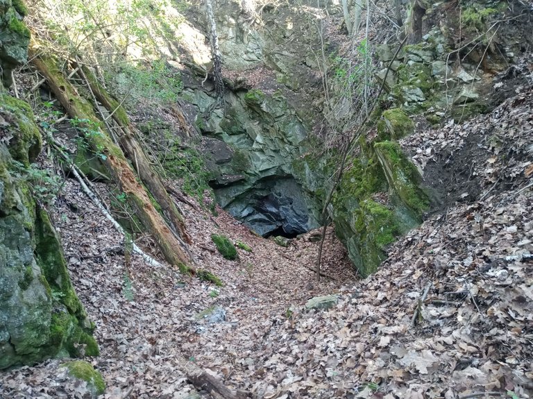
Uprostřed malého lesíku mě překvapila hluboká proláklina. To stálo za průzkum. Obešel jsem „díru“, našel vhodný přístup a vstoupil do dolního konce prolákliny. Na jejím konci se mi naskytl pohled, který mi „rozbušil srdce“.
Uprostřed malého lesíku mě překvapila hluboká proláklina. To stálo za průzkum. Obešel jsem „díru“, našel vhodný přístup a vstoupil do dolního konce prolákliny. Na jejím konci se mi naskytl pohled, který mi „rozbušil srdce“.
I ended up on an inconspicuous hill actually by accident (if there are coincidences, some say they don't), while looking for an access road to the river.
In the middle of a small forest, I was surprised by a deep depression. It was worth exploring. I went around the "hole", found a suitable approach and entered the lower end of the depression. At the end of it, I was greeted by a view that "made my heart beat faster".
In the middle of a small forest, I was surprised by a deep depression. It was worth exploring. I went around the "hole", found a suitable approach and entered the lower end of the depression. At the end of it, I was greeted by a view that "made my heart beat faster".
JESKYNĚ!!
Podle mapy tady však nic takového být nemělo!
Opatrně jsem sestoupil dovnitř. Nouzově si posvítil mobilem, udělal nazdařbůh fotku s bleskem a rozhodl se odložit průzkum na neděli s lepším světelným vybavením.
Podle mapy tady však nic takového být nemělo!
Opatrně jsem sestoupil dovnitř. Nouzově si posvítil mobilem, udělal nazdařbůh fotku s bleskem a rozhodl se odložit průzkum na neděli s lepším světelným vybavením.
A CAVE!!
However, according to the map, there was nothing like that here!
I carefully descended inside. He used his mobile phone to make an emergency light, took a random photo with a flash and decided to postpone the exploration until Sunday with better lighting equipment.
However, according to the map, there was nothing like that here!
I carefully descended inside. He used his mobile phone to make an emergency light, took a random photo with a flash and decided to postpone the exploration until Sunday with better lighting equipment.
Nedělní dopoledne padlo na procházení map. Geologická mapa mi prozradila, že v dané lokalitě je pararula, což není zrovna ideální hornina pro tvorbu jeskyní. Ale nedaleko odtud končila „vložka (vrstva)“ krystalického vápence a v tom se jeskyně vyskytují dost často. Ostatně v reálu bylo vidět, že nadloží je jiné než vstup do jeskyně.
Sunday morning was spent browsing maps. The geological map revealed that the locality was covered in pararula, which is not exactly the ideal rock for cave formation. But not far from there, a “layer” of crystalline limestone ended, and caves are quite common in this. In reality, it was clear that the overlying rock was different from the cave entrance.
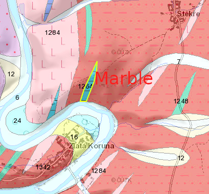
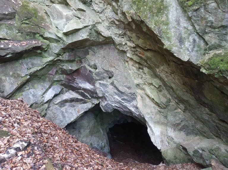
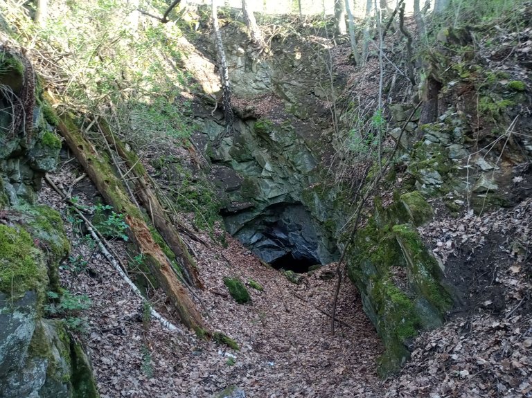
Proláklina byla vlastně starý lom, o kterém jsem však nenašel nikde žádnou zmínku. Vstup do jeskyně byl očividně „prolámán“ až mnohem později po ukončení těžby kamene.
V neděli odpoledne jsme byli se Sue znovu u jeskyně, vybaveni pořádným světlem a pro jistotu i lanem.
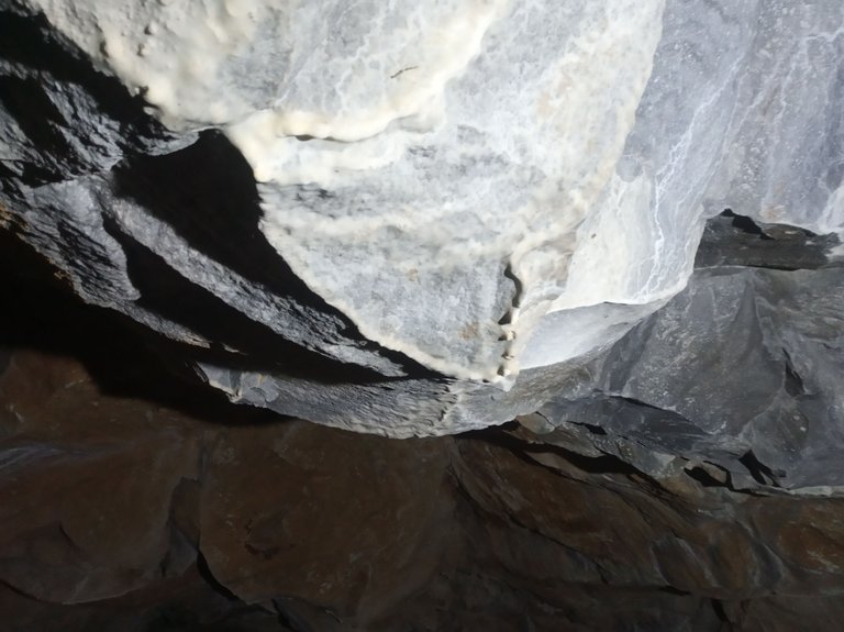
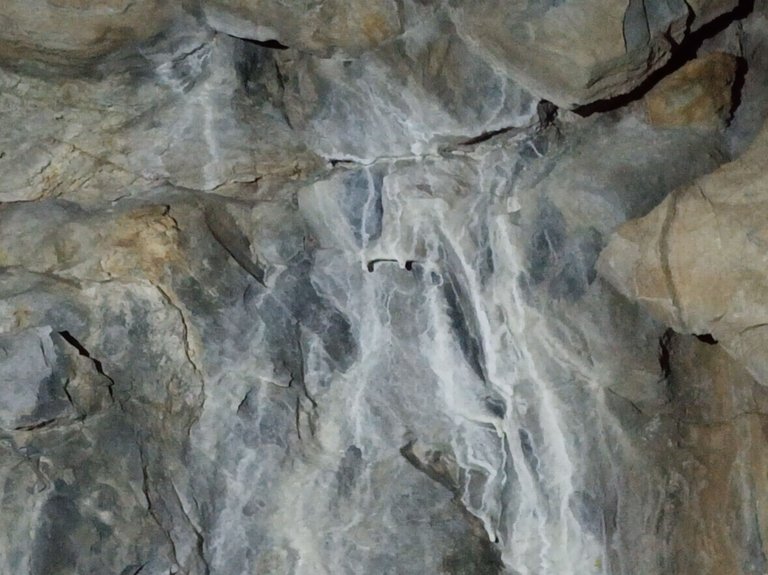
Znovu jsem pořádně prohlédl vstup. Kvalitní šedý mramor nesl stopy po vrtání a skoro žádné stopy po zvětrávání.
V neděli odpoledne jsme byli se Sue znovu u jeskyně, vybaveni pořádným světlem a pro jistotu i lanem.
Znovu jsem pořádně prohlédl vstup. Kvalitní šedý mramor nesl stopy po vrtání a skoro žádné stopy po zvětrávání.
The depression was actually an old quarry, but I couldn’t find any mention of it anywhere. The cave entrance was apparently “broken” much later, after the stone mining had stopped.
On Sunday afternoon, Sue and I were back at the cave, equipped with a proper light and, just to be safe, a rope.
I took another good look at the entrance. The high-quality gray marble bore signs of drilling and almost no signs of weathering.
On Sunday afternoon, Sue and I were back at the cave, equipped with a proper light and, just to be safe, a rope.
I took another good look at the entrance. The high-quality gray marble bore signs of drilling and almost no signs of weathering.

Z toho jsem usoudil, že vstup byl prolámán nejpozději v druhé polovině minulého století.
Dost bylo teoretizování. Jdeme se podívat dovnitř.
Dost bylo teoretizování. Jdeme se podívat dovnitř.
From this I concluded that the entrance was broken through no later than the second half of the last century.
Enough theorizing. Let's go take a look inside.
Enough theorizing. Let's go take a look inside.
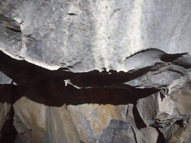
Jeskyně má asi tyto rozměry:
výška – 4 až 5 metrů
šířka – také tak
délka asi 15 metrů
výška – 4 až 5 metrů
šířka – také tak
délka asi 15 metrů
The cave has approximately the following dimensions:
height – 4 to 5 meters
width – the same
length about 15 meters
height – 4 to 5 meters
width – the same
length about 15 meters

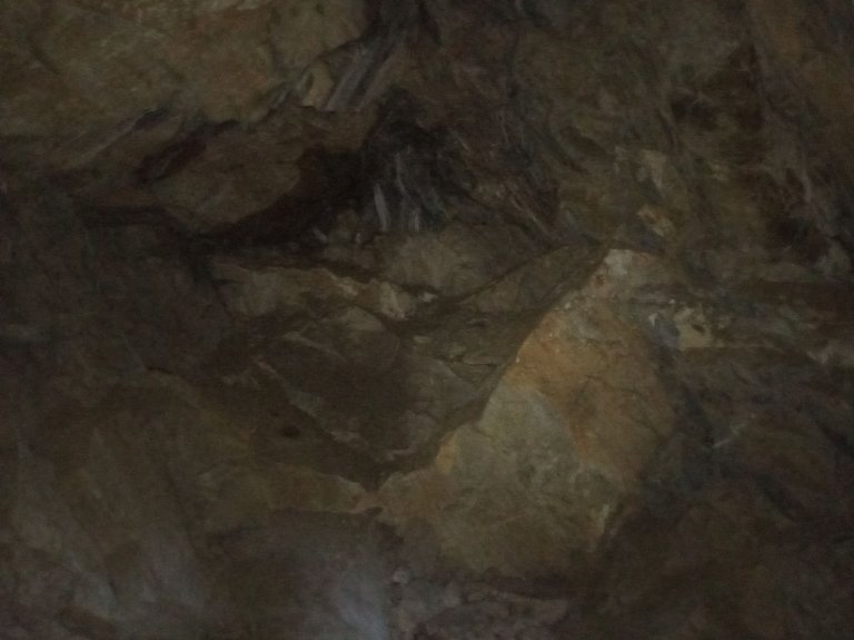
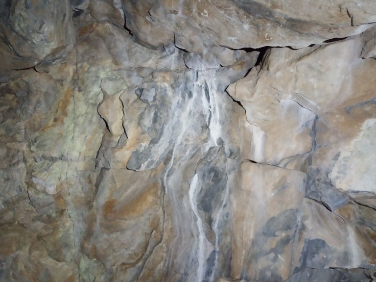
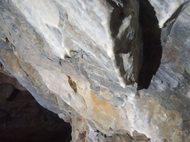
Na stropu a stěnách se, díky prosakující vodě, tvoří stalaktity a sintrový povlak. Některé hrany vykazují náznak vzniku „záclon“.
Due to seeping water, stalactites and a sinter coating form on the ceiling and walls. Some edges show signs of "curtains".
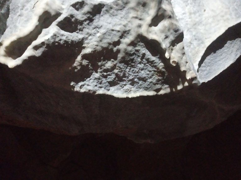
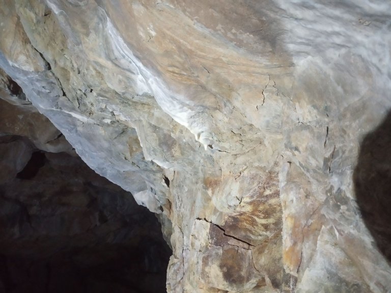
Pokud nezasáhne zlovolná lidská ruka nebo se jeskyně nezřítí, bude tady časem obstojná krápníková výzdoba.
Doufám, že místní skřítek si jeskyni pohlídá a nedovolí její zničení :-)
Doufám, že místní skřítek si jeskyni pohlídá a nedovolí její zničení :-)
Unless a malicious human hand intervenes or the cave collapses, there will be a decent stalactite decoration here in time.
I hope that the local elf will watch over the cave and not allow it to be destroyed :-)
I hope that the local elf will watch over the cave and not allow it to be destroyed :-)
Abych nezapomněl. Od 22.4. je na mapách na serveru mapy.cz jeskyně označená.
Just so I don't forget. Since April 22, the cave has been marked on the maps on the mapy.cz server.
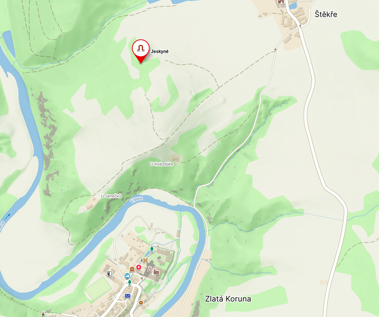
Pokud tedy někdy zavítáte do jižních Čech do okolí Českého Krumlova a budete hledat nějaké zajímavé místo mimo rušných turistických tras, můžete zkontrolovat, jak „povyrostly“ krápníky v jeskyni od doby mého „prvotního“ průzkumu.
So if you ever visit South Bohemia, around Český Krumlov, and are looking for some interesting place off the beaten tourist trail, you can check how the stalactites in the cave have "grown" since my "initial" exploration.

cesky
traveladvice
worldmappin
liketu
photographylovers
travel
amazingnaturean
aroundtheworld
waiv
pob
0
0
0.000
You can check out this post and your own profile on the map. Be part of the Worldmappin Community and join our Discord Channel to get in touch with other travelers, ask questions or just be updated on our latest features.
Congratulations, your post has been added to the TravelFeed Map! 🎉🥳🌴
Did you know you have your own profile map?
And every post has their own map too!
Want to have your post on the map too?
- Go to TravelFeed Map
- Click the create pin button
- Drag the marker to where your post should be. Zoom in if needed or use the search bar (top right).
- Copy and paste the generated code in your post (any Hive frontend)
- Or login with Hive Keychain or Hivesigner and click "create post" to post to Hive directly from TravelFeed
- Congrats, your post is now on the map!
PS: You can import your previous Pinmapple posts to the TravelFeed map.Opt Out
It looks like the place you visited is a bit scary! That's what I think. You are very confident and enthusiastic about going there. What an adventure my friend. Cool!
Such spaces scare me less than a street full of people :-)
I was really excited. I felt like a "great discoverer" :-D
you are so awesome! finding unique and interesting spaces is definitely a fun experience. I hope you continue to find new and interesting things. have a great day.
I plan to write about one more interesting place :-).
Have a great weekend
That's a great idea. You too!
:-)
https://peakd.com/hive-184437/@bucipuci/around-the-world-challenge-515
Pěkné podzemní prostory. Trochu mi to připomíná Lazurovou horu u Michalových Hor...
Dost mě to překvapilo. Čekal jsem nějakou "kapsu" a ona to je opravdu slušná jeskyně. Navíc to vypadá na přírodní dutinu. Vylámaný je evidentně jenom vstup.
Máš na tu Lazurovou odkaz nebo aspoň mapu?
https://www.tachov-mesto.cz/prirodni-rezervace-lazurovy-vrch.html
https://mapy.com/s/juketecasu
Mrknu na to. Díky :-)
Není zač. Je to zajímavá oblast, značně liduprázdná. I když teď nevím. Byl jsem tam cca před dvaceti lety.
Vypadá to, že ten kopec je "děravý jako Ementál" :-). Škoda, že je to pro mne trochu z ruky.
Pro mě taky. Je to každopádně zajímavá lokalita.
:-)
Congratulations @bucipuci! You received the biggest smile and some love from TravelFeed! Keep up the amazing blog. 😍 Your post was also chosen as top pick of the day and is now featured on the TravelFeed front page.
Thanks for using TravelFeed!
@for91days (TravelFeed team)
PS: Did you know that we have our own Hive frontend at TravelFeed.com? For your next travel post, log in to TravelFeed with Hive Keychain or Hivesigner and take advantage of our exclusive features for travel bloggers.
I'm glad you like my articles.
Thank you for your support @for91fays and @travelfeed